
British Columbia Part 4: Desolation Sound & Surrounding Region
- Madeleine Baisburd

- Sep 14, 2024
- 5 min read
Updated: Oct 14, 2024
Leaving Cortes Bay, we headed northeast into the breathtaking beauty of Desolation Sound. We were leaving behind all roads, the electric grid, and humanmade structures for at least a few weeks, and we were ready.
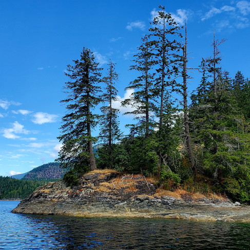
Desolation Sound is a world-renowned wilderness area known for its protected waters, diverse and abundant marine life, and stunning shorelines. Verdant mountains rise majestically out of mirror-like depths layered in blue dimensions as far as the eye can see. Here, the world is uninterrupted by internet towers or hydro lines. Occasional cabins and docks eventually give way to pristine nature as the coastline slips by.
As we passed through a primeval gateway between two jutting points, low-hanging clouds shrouded portions of the distant peaks, giving the illusion that some of them were hovering, other-worldly, in the muted morning light :

Both Nico and I deeply crave contact with untouched wilderness and could feel our hearts and souls opening to the spectacular peace of the region. Our whole family was spellbound as we rounded each point to take in new vistas, one more uplifting than the next:


Teakerne Arm

Our first anchorage in the Desolation Sound region was Teakerne Arm--a narrow bay surrounded by steep, rocky shoreline that seamlessly transforms into soaring, forested slopes. We opted to stretch our legs with a picnic dinner off the boat and the kids decided this would be the perfect moment for a full-blown stuffy party. So, into the dinghy went all of their stuffies and we sat out on a rocky bluff together watching the tide rise and the sun set, enjoying pasta with pesto, and being treated to a truly unique dinner theatre as the stuffies performed impromptu shows for us. It was quirky, incongruous, unexpected, and delightfully special.
The next day, after putting in some work on our sputtering dinghy engine, we visited Teakerne Arm's main attraction--a beautiful waterfall that pours out of Cassel Lake directly into the sea. The falls is best viewed from the water by boat, but can also be seen from above on the short, steep hike up to Cassel Lake. For a mountain reservoir, the lake's clear water is surprisingly warm and we all enjoyed floating on our backs surrounded by a 360-degree view of deep blue peaks. Nico and I took turns swimming across to the far shore (about 1 km round trip) while the kids made friends with some other boaters and collected rocks on the cliffs.


Tenedos Bay
Our next remote anchorage was in Tenedos Bay, southeast of Teakerne Arm, and only accessible via another gorgeous sail around the southern tip of West Redonda Island. Here, we tied our stern to shore just a few meters from the rock face of a cliff where purple Ochre Sea Stars and burgundy Leather Stars clung within the vertical intertidal zone. For Nico, it has taken some getting used to to realize that, in this region of the Pacific Northwest, steep underwater geography means that depths just a few meters off shore can reach more than 100 feet. I could see him shaking his head as he surveyed Mohini's proximity to solid land.
The major draw near Tenedos Bay is a series of freshwater lakes, the largest and most accessible of which is Unwin Lake. This completely undeveloped body of water offers incredible opportunities for swimming, paddling, or simply sitting cliffside and watching reflections of clouds dancing over the mountain peaks. After dragging our dinghy up the rough beach to secure it at low tide (we have portable wheels to help with tasks like this), we accessed Unwin lake via a well established trail that took us past a swift little stream with a magical pour-over where the kids stopped to rock-hop and float leaf boats down the rapids.


From there, we picked our way to a natural overlook where we fueled up with a hearty lunch in anticipation of the long hike to come. The Unwin Lake to Melanie Cove trail proved to be highly technical, with lots of steep cliff scrambles and sheer drop-offs. Both kids were troopers and tackled the challenges with determination, but after Yael fell and skinned her knee for about the 11th time in 10 minutes near the shores of the third lake, we realized it was time to turn back. We'd made excellent progress given the difficulty of the trail, but reaching Melanie Cove by foot is an adventure we'll have to revisit again in the future. We returned to Lake Unwin for a late afternoon dip with tired legs and full hearts. It was a truly beautiful day.

Walsh Cove
We'd heard that there were petroglyphs not far away and so, after a couple more nights spent in Tenedos Bay, we sailed over to Walsh Cove Park where we anchored between the east side of West Redonda Island and the tiny Gorges Islands. This wasn't an anchorage we'd researched in advance, but it turned out to be one of my favourites of our entire backcountry adventure.
The water around Walsh cove is crystal clear and emerald green in the sunlight. Barnacle and oyster-covered shores give rise to craggy, evergreen-covered heights where Bald Eagles circle in updrafts and the sun's rays create exquisite silhouettes at sunrise and sunset. There are no groomed trails in this area, but you can scramble up to the ridgeline to walk the length of several small islands at low tide with panoramic views of the windswept channel, cliff faces, and sparkling sea. This was the only place I hopped in the water for a cold but refreshing swim, enjoying a brisk series of laps between the shore and Mohini's stern.


We located the petroglyphs just around the point from where we were anchored and spent some time searching for more ancient markings as the tide receded down the cliff face. Later that day, we were also fortunate to connect with another family sailing with kids on board. We hosted an afternoon playdate on Mohini and the kids spent the evening crushing berries and shells to create "barnacle stew" in small tidepools.
Von Donop Inlet

From Walsh Cove, we sailed around the northern tip of Cortes Island and into the dreamlike seclusion of Ha'thayim Marine Provincial Park. The afternoon we arrived was a cold, rainy one and low-hanging mist obscured the shoreline as we passed through the narrow entrance to Von Donop Inlet, which is only navigable at higher tides.
Despite the rain, we had a bit of cabin fever and spent the afternoon squelching through slippery, and somewhat pungent, mud flats exposed at low tide to reveal thousands of clams and snails. The kids collected shells and we enjoyed huddling under a cedar tree whose ancient branches provided protection from the raindrops.
The next day was brighter and, after doing some work and boat chores in the morning, we headed to shore to see if we could locate a hiking trail. Coincidentally, our friends from Walsh Cove appeared on the beach as we landed and invited us to hike back to their anchorage at Squirrel Cove with them. It was a lovely hike through old and second-growth cedar forest, and the children were thrilled to score a second playdate with their sailing buddies.
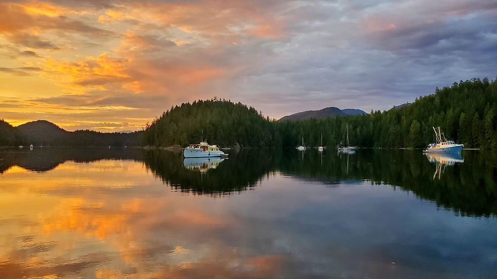
That evening, the water in Von Donop Inlet was like glass and we were treated to a truly spectacular sunset:
We'd now been in remote areas for about two and a half weeks. We weren't feeling done by any means, but we needed a few supplies and decided to scoot down to Gorge Harbour on Cortes Island's west coast before continuing our wilderness adventures. In addition, the weather was changing and we were starting to gauge how much time we really had left before turning our bow southward would become a necessity.
To continue following Mohini's adventures, read our next post, British Columbia Part 5: The Last Leg of the Journey.


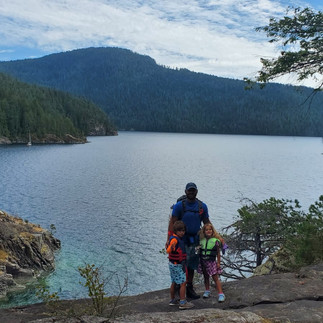
That's my girl!